 01
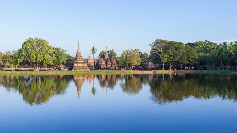
Wat MahathatThe city's heart with a lotus-bud chedi
SUKHOTHAI · WORLD HERITAGE
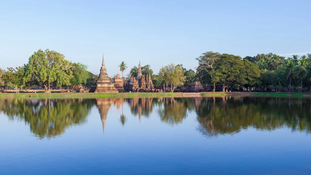
The World Heritage ruins of Sukhothai, capital of a 13th–15th-century Thai kingdom, with nearly 200 monuments across about 70 km²
Holiday / event — crowded · Hot (Afternoon) feels like 40°C
Daily 06:30–19:30
20 THB
Half a day to a full day
Loy Krathong in November is busiest, followed by cool-season long weekends
01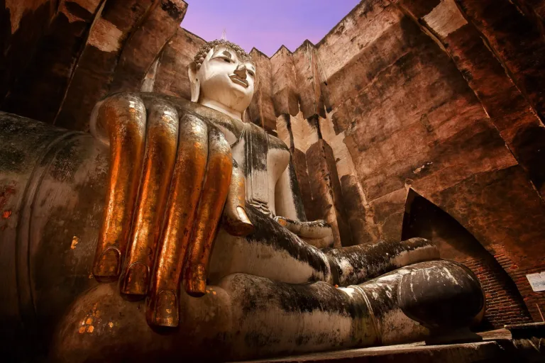 02
 03
 04
 05
Tap a day card to see that day’s weather, rain, haze and hourly forecast
Best time to go Fine all day little rain through the day
Holiday — traffic on the way up and parking fills fast; leave early
Green band = hours used for the score
Best time to go Fine all day little rain through the day
Extreme heat — feels like 41°C; avoid midday sun and drink often
Holiday — traffic on the way up and parking fills fast; leave early
Green band = hours used for the score
Best time to go Fine all day little rain through the day
Holiday — traffic on the way up and parking fills fast; leave early
Green band = hours used for the score
Best time to go Best window 06:00–16:00 Little rain · light drizzle possible at times
No warnings today — normal road and weather conditions
Green band = hours used for the score
Best time to go Fine all day little rain through the day · light drizzle possible at times
No warnings today — normal road and weather conditions
Green band = hours used for the score
Best time to go Fine all day little rain through the day · light drizzle possible at times
No warnings today — normal road and weather conditions
Green band = hours used for the score
Best time to go Fine all day little rain through the day
No warnings today — normal road and weather conditions
Green band = hours used for the score
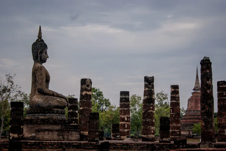
Sukhothai Historical Park preserves the old capital of the Sukhothai kingdom, which flourished from the 13th to the 15th century. Its walled city and surroundings hold nearly 200 monuments over about 70 km², including Wat Mahathat, Wat Si Chum and Wat Sa Si.
Inscribed as a World Heritage Site in 1991, it is best explored by bicycle in the cool season, and every November it hosts the Loy Krathong candle and fire festival.
Photos from Wikimedia Commons and contributors · full credits inClassic page
Do not climb or sit on Buddha images or ruins, or pose disrespectfully
Very little shade; bring water, a hat and sunscreen
Watch for traffic on the main road through the old city
Students, clergy and people aged 60+ enter free
Adults 20 THB · Car 50 THB · Time needed Half a day to a full day
Loy Krathong in November is busiest, followed by cool-season long weekends
| Thai visitor entry (per zone) | 20 ฿/person |
| Thai combined ticket optional | 40 ฿/person |
| Foreign visitor entry, inner zone (latest source) | 200 ฿/person |
| Foreign visitor entry, outer zone (latest source) optional | 120 ฿/person |
| Bicycle per zone optional | 10 ฿/bike |
| Motorbike per zone optional | 20 ฿/bike |
| Car (Wat Phra Phai Luang and Aranyik zone only) optional | 50 ฿/car |
Mostly cash · Prices may change by season — check with the venue
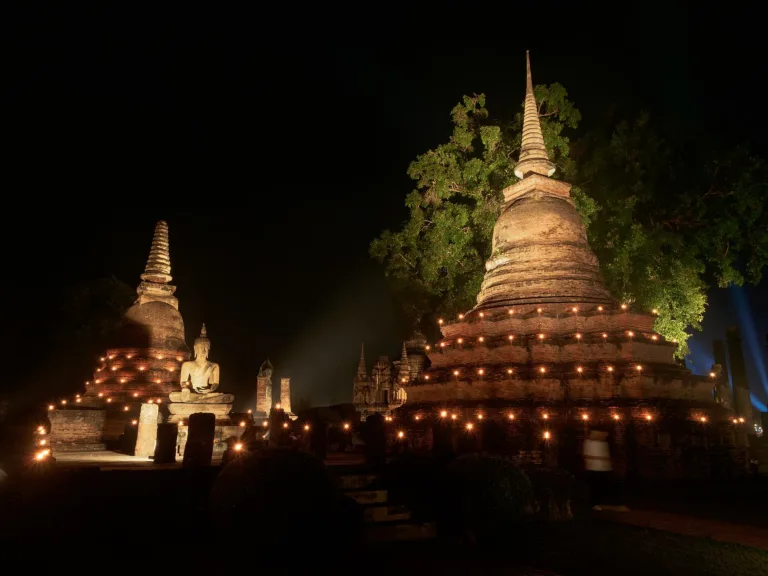
Loy Krathong candle and fire festival (around the full moon of the 12th month, about November)
Tap a month on the wheel to see weather, rain, haze and crowds from 10 years of records
Best time · November to February is cool and clear, ideal for cycling all day, and November brings the Loy Krathong candle and fire festival, the most beautiful but most crowded time of year.
Watch out · March to May is very hot and the open-air ruins have little shade, so visit at dawn or dusk; in some rainy seasons the Sukhothai plain floods.
Oct by the records 24–31°C · avg rain 198 mm (20 rainy days) · clear 7 days · avg PM2.5 10
Sukhothai Historical Park lies in Mueang Kao subdistrict, about 12 km from today's Sukhothai town. It covers the old city of Sukhothai, a royal capital that flourished from the 13th to the 15th century before being absorbed by Ayutthaya in the 15th century. The Fine Arts Department defined the monument zone as 43,750 rai, about 70 km².
The city sits on a plain at the foot of hills that slopes east, with the Prathak range to the west supplying minerals and headwaters. The Mae Lamphan canal, rising in Lampang, flows past the city to join the Yom River about 12 km east. The square city is enclosed by three earthen ramparts separated by moats; the inner wall measures about 1,600 m by 1,800 m. The inner wall likely dates from the city's founding, while the middle and outer ones were probably added under Ayutthaya rule. Inside are many traphang (ponds) that served as water supplies.
Water management was the heart of the city. The "Saritphong", or Thamnop Phra Ruang dam, lies about 2 km southwest of the city walls between the Kiw Ai Ma pass and Khao Phra Bat Yai in the Prathak range. It gathered water from about 17 mountain streams, such as Sok Phra Ruang Long Khan, Sok Phra Ruang Lap Khan and Sok Chomphu, and diverted it along Khlong Sao Ho to the city moat at the southwest corner, the city's highest point. From there water flowed through all four moats and the city's ponds to the northeast corner, the lowest point, then into the Mae Lamphan canal and the Yom River. The name Saritphong comes from Inscription No. 1. The Royal Irrigation Department and the Fine Arts Department have rebuilt the dam to about 10 m high, holding about 400,000 m³, while the original earthen dikes were only 1–2 m high, so some scholars think they diverted flash floods away from the city rather than storing water.
Another puzzle is the "Phra Ruang Road", an earthen embankment about 123 km long linking Kamphaeng Phet, Sukhothai and Si Satchanalai. Legend says King Phra Ruang dragged his foot from Khao Luang to make it. The name first appears in writing in King Chulalongkorn's 1906 travel account. Scholars still disagree: some see it as a main trade road, others as an irrigation canal, since the ground falls steadily from about 79 m at Kamphaeng Phet to 49 m at Sukhothai, while excavations by Charuk Wilaikaew in 1992–2002 suggest a flood dike balancing water and farmland. The question remains open.
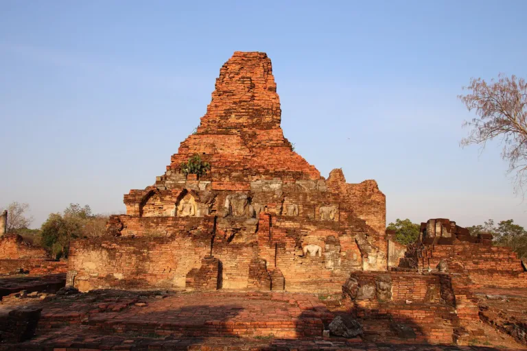
People lived here long before the kingdom: stone tools and prehistoric skeletons have been found. Around the 7th century Dvaravati culture arrived, and in the 12th–13th centuries Khmer culture spread here, seen in the prasat of Wat Phra Phai Luang, the Ta Pha Daeng shrine and Wat Si Sawai. Scholars believe the first city centre lay to the north around Wat Phra Phai Luang before a new city was built further south.
Inscription No. 2 says that Pho Khun Bang Klang Hao, with Pho Khun Pha Mueang, drove out Khmer rule and became king of Sukhothai as Pho Khun Si Intharathit, founder of the Phra Ruang dynasty. Historians place this in the mid-13th century (around 1237–1240).
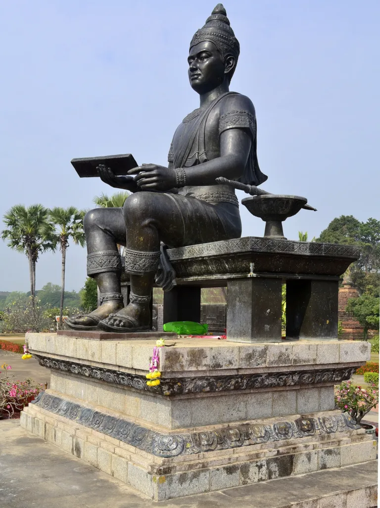
Under King Ramkhamhaeng the city centre moved to Wat Mahathat, the realm expanded through vassal relationships, and Sri Lankan Theravada Buddhism arrived via Nakhon Si Thammarat. Inscription No. 1, dated 1292, describes the creation of the Thai script, a land of plenty with "fish in the water and rice in the fields", and a festival of "burning candles and playing with fire".
King Mongkut, then a monk on pilgrimage, found Inscription No. 1 on 17 January 1833, and the Thai cabinet later made that date King Ramkhamhaeng the Great Day. The inscription is displayed at the National Museum Bangkok and was inscribed on UNESCO's Memory of the World register in 2003, though some scholars have questioned its authenticity and date, an academic debate that continues.
Around 1347 King Maha Thammaracha Lithai reunited the Sukhothai realm. He patronised Buddhism, wrote the cosmological treatise Traiphum Phra Ruang and was ordained at Wat Pa Mamuang. This was the high point of Sukhothai art, above all the walking Buddha, the period's most distinctive free-standing sculpture, and the lotus-bud chedi, which became a hallmark and spread to Kamphaeng Phet, Chiang Mai and Phitsanulok.
With Ayutthaya founded in 1350 and Lanna growing stronger in the north, Sukhothai declined. After Lithai's death around 1370–1371, King Borommaracha I (Khun Luang Pha Ngua) of Ayutthaya took Sukhothai and other towns, and in 1438 the whole realm became part of Ayutthaya, with Prince Ramesuan governing Phitsanulok as viceroy.
Wat Mahathat, the city's most important temple, was laid out on a cosmological plan. Its lotus-bud main chedi is surrounded by eight subsidiary chedis and about 200 smaller ones; stucco disciples walk in procession around its base, and tall standing Phra Attharot images stand in the viharns. Inscription No. 1 mentions a golden Buddha in the city centre, thought to be a bronze Buddha in the subduing-Mara posture probably cast under Lithai around 1362. In the reign of Rama I it was floated by raft to the main viharn of Wat Suthat in Bangkok, and Rama II named it "Phra Si Sakyamuni"; its huge base remains at Wat Mahathat.
Wat Si Chum, north of the walls, has a tall mondop enclosing "Phra Achana", a giant seated Buddha in the subduing-Mara posture with a lap width of about 11 m, a name that appears in Inscription No. 1. A passage inside the mondop wall holds many slate slabs incised with Jataka scenes, and a story tells that someone once spoke from inside the wall so that the Buddha seemed to talk, to rally soldiers. Pierre Pichard of the École française d'Extrême-Orient, after a detailed survey, proposed in 2009 that the mondop may have been left unfinished. In 2018 Wat Si Chum sued the Fine Arts Department over land around the Phra Achana mondop, and the department ordered unpermitted buildings in the monument zone removed, a case that reflects the tension between living temples and a World Heritage Site.
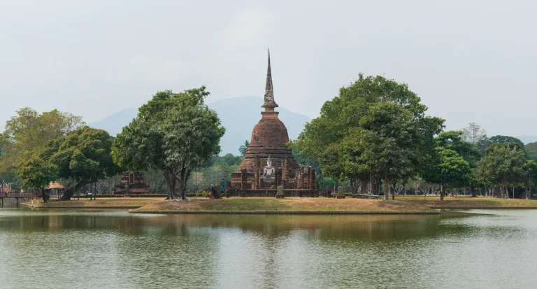
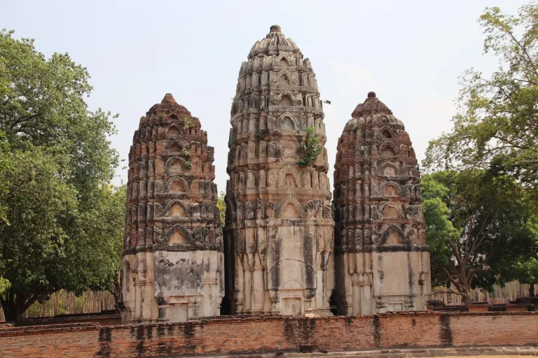
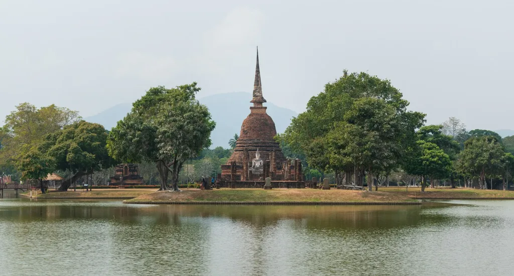
Other key monuments include Wat Si Sawai, three Lopburi-style prangs from a former Hindu shrine converted into a temple; Wat Sa Si, a Sri Lankan-style chedi on an island in the Traphang Trakuan pond; Wat Traphang Ngoen; Wat Phra Phai Luang, with laterite Bayon-style prangs to the north; Wat Saphan Hin on a western hill, where a slate path climbs to a standing Phra Attharot; and Wat Chang Lom, with stucco elephants around its chedi base. To the north are kilns for Sangkhalok ceramics.
Wat Si Sawai has a different story from the other temples. Prince Damrong suggested its original name was "Si Siwaya", referring to Shiva. In 1907 the future King Vajiravudh, then crown prince, found a Shiva image in the viharn and a wooden post in the ordination hall, and suggested it had been a Brahmin shrine used for the swing ceremony before becoming a Buddhist temple. It probably dates from the 13th century, with additions in the Ayutthaya period. Its three prangs have laterite bases and brick bodies and face south, unlike most Sukhothai monuments, which face east; each base is 6.5 m wide, and the eastern prang has murals inside. The viharn in front, 14 by 22 m, has wall slits typical of late Sukhothai to early Ayutthaya, the laterite temple wall measures 106.5 by 117.5 m, and a half-moon pond is known locally as the "Sa Loi Bap", the pond for floating away sins.
Sukhothai was also a major ceramic centre. The Thuriang kiln site lies north of the city around Wat Phra Phai Luang. In a Fine Arts Department conservation project begun in fiscal 2016, 64 kilns were found: 52 updraft kilns firing below 800°C and 12 cross-draft kilns firing at 900–1,200°C. Sukhothai wares have a white slip with black painting under a clear glaze, most famously fish, from a single fish to four on one dish. Radiocarbon dating at the University of Waikato, New Zealand, places the early phase about 600 years ago under King Lithai and a later phase about 550 years ago, when many kilns were built for export and the painting became less refined. Goods probably travelled by the Mae Lamphan canal to the Yom River and by cart along the Phra Ruang Road. In 2020 the department built nine bamboo shelters over the kilns to protect them.
Sukhothai's status as "the first Thai capital" took clear shape in the early 20th century. In 1907 King Chulalongkorn founded the Archaeological Society to research history before Ayutthaya. Around 1907–1908 Crown Prince Vajiravudh inspected the northern monuments and wrote "Thiao Mueang Phra Ruang" (Touring the Land of Phra Ruang), linking Sukhothai to the Thai nation. In 1914 Prince Damrong divided Thai history into the Sukhothai, Ayutthaya and Rattanakosin periods. Later historians such as Warisara Tangkhawanit argue that this narrative was both a discovery and a "construction" of national history, made to appear unified and continuous.
The Fine Arts Department began surveying and registered 75 monuments in 1935. In 1953 Field Marshal Plaek Phibunsongkhram's government set up a committee to restore Sukhothai, starting with excavation of Wat Mahathat, which uncovered stucco disciples, a gold-sheet inscription in the five-spired chedi believed to hold Lithai's ashes, and many artefacts now in the Ramkhamhaeng National Museum. A second phase ran from 1965 to 1969, and in 1975 the 43,750-rai monument zone was declared.
In 1976 the department began a master plan for the "Sukhothai Historical Park Project" under the 4th and 5th National Economic and Social Development Plans, which the cabinet approved. The park officially opened on 20 November 1988, when Princess Maha Chakri Sirindhorn presided on behalf of King Bhumibol to mark his fifth-cycle birthday.
On 12 December 1991 the 15th session of the World Heritage Committee in Carthage, Tunisia, inscribed the "Historic Town of Sukhothai and Associated Historic Towns" (Sukhothai, Si Satchanalai and Kamphaeng Phet) as cultural World Heritage Site No. 574 under criteria (i) and (iii), covering 74,075 rai in total. Surveys have recorded about 193–217 monuments in Sukhothai, inside the walls and outside on all four sides.
The Loy Krathong candle and fire festival is Sukhothai's best-known annual event, with light-and-sound shows among the ruins, lamps and krathong floated on the ponds, and the Nang Noppamas pageant. Historians note, however, that the inscription mentions only "burning candles and playing with fire", not floating krathong, and that the tale of Nang Noppamas (Tamrap Thao Si Chulalak) was written in the early Rattanakosin period with a Sukhothai setting. The 2023 festival, held from 18 to 27 November, drew more than 340,000 visitors as the government promoted it as a national soft-power event, with a candle ceremony at the King Ramkhamhaeng monument, fireworks and fire displays at Traphang Trakuan and a light-and-sound show on Thao Si Chulalak at Wat Mahathat.
Today the park is divided into ticketed zones: the inner (central) zone, the northern outer zone (Wat Si Chum to Wat Phra Phai Luang) and the western Aranyik zone (Wat Saphan Hin). It is open daily from 06:30 to 19:30. Many visitors explore by bicycle, and monks collect morning alms at Wat Traphang Thong.
Visitors should dress modestly, never climb or sit on Buddha images or ruins, and avoid disrespectful poses in photos, to protect this World Heritage Site that shaped Thai art.
Arrived? Check in, collect a stamp and tell others what it is like right now
Check your location first, so you do not fill in the form for nothing
Location must be on and within 3 km · One check-in per place per day · come back on other days to check in again
Post photos from anywhere — no need to be here · Up to 20 photos at a time · JPG / PNG / WebP · GPS location data is removed automatically
From Sukhothai town (New Sukhothai) take Highway 12 west abo…
Highway 12, about 12 km · Fuel
Town–old city · Standard fare
Inside the park · Varies by shop
From Sukhothai town take Highway 12 west about 12 km to the old city
Car park by the central zone, near bicycle rentals and the Ramkhamhaeng National Museum
Petrol stations on Highway 12 and around the old city
Good mobile signal throughout
Daily 06:30–19:30
around 12 km fromSukhothai town (New Sukhothai)
Sukhothai Historical Park
Approx. nightly price for 2 adults (next week) · final price depends on your dates
Best day this week: Thursday 29 Oct · Check in when you arrive to collect a stamp