High-water season, safety and time needed
Jun – Oct (wettest)
Limestone tiers — Very slippery, especially in the rains
About 08:00–17:00
Half a day to a day
6 days ahead
When to go
this week
Tap a day card to see that day’s weather, rain, haze and hourly forecast
Best time to go Fine all day little rain through the day · light drizzle possible at times
Holiday — traffic on the way up and parking fills fast; leave early
Hour by hour
Green band = hours used for the score
Best time to go Best window 06:00–16:00 Little rain · light drizzle possible at times
Holiday — traffic on the way up and parking fills fast; leave early
Hour by hour
Green band = hours used for the score
Best time to go Best window 06:00–17:00 Little rain · light drizzle possible at times
Holiday — traffic on the way up and parking fills fast; leave early
Hour by hour
Green band = hours used for the score
Best time to go Fine all day little rain through the day · light drizzle possible at times
No warnings today — normal road and weather conditions
Hour by hour
Green band = hours used for the score
Best time to go Fine all day little rain through the day · light drizzle possible at times
No warnings today — normal road and weather conditions
Hour by hour
Green band = hours used for the score
Best time to go Fine all day little rain through the day
No warnings today — normal road and weather conditions
Hour by hour
Green band = hours used for the score
Starry sky
How likely
Scored from cloud cover at every level and tonight’s moonlight — the darker the sky, the clearer the Milky Way · tap another night below for the next 7 nights
Namtok Pha Charoen National Park
Namtok Pha Charoen National Park, Chong Khaep, Phop Phra, Tak.
- Mist at Doi Kia (cool season)
- Good light on the falls
- Strong sun
- Hot-spring soak
Mist at Doi Kia in the cool season
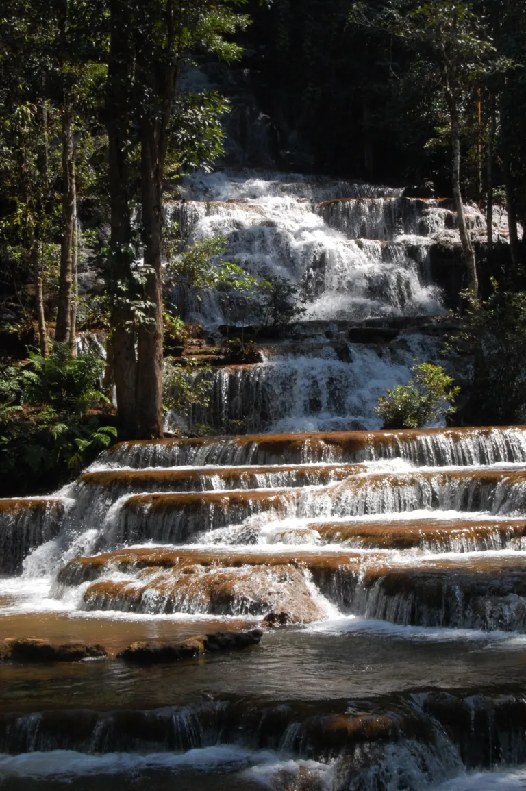
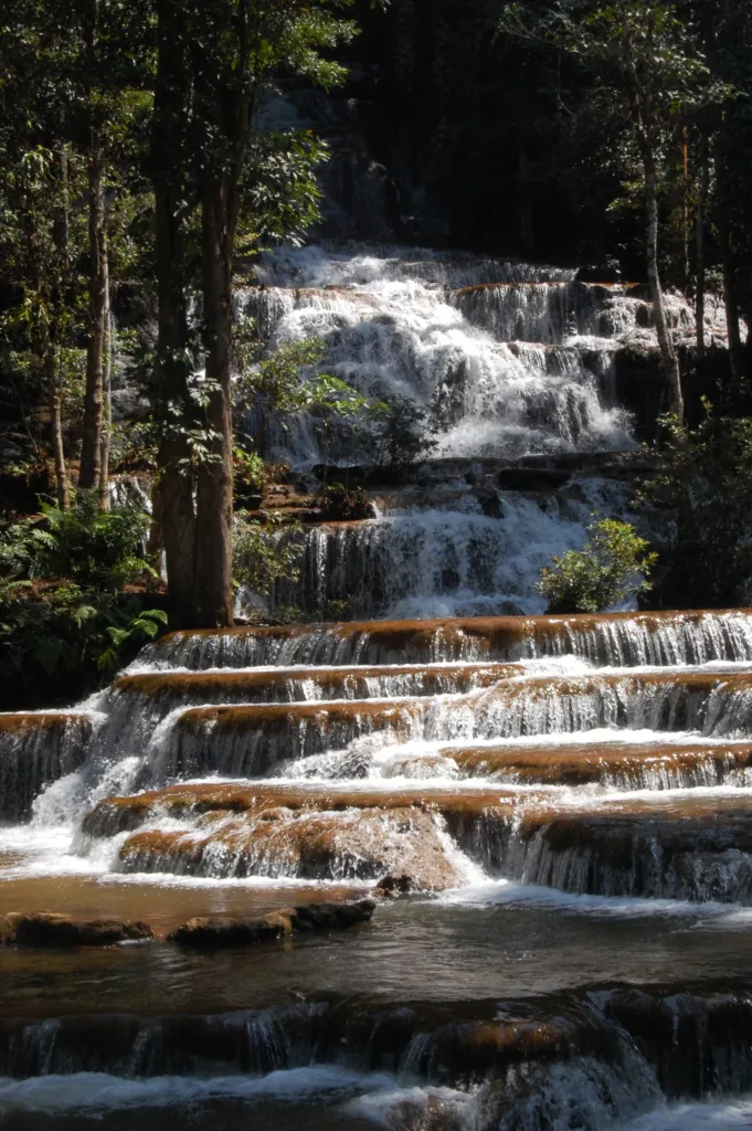
- Pha Charoen fallsLimestone tiersLate morning
- Curcuma fieldFull bloomMorning
- Doi KiaSea of mistMorning
Gallery
Photos from Wikimedia Commons and contributors · full credits inClassic page
Good to know here
Very slippery, especially in the rains
Don't approach the shaft without staff
Winding mountain road; landslide risk in heavy rain
Don't pick or trample
- Wear grippy shoes
- Visit Doi Kia at dawn in the cool season
- Call ahead about fees and lodging
- Check brakes and tyres before Highway 1090
- · Time needed Half a day to a day
Curcuma season and cool-season holidays
- Kids Yes at the lower pool and curcuma field
- Seniors Yes at the lower tiers
- Wheelchair Walkway to the lower viewing area
- Pets Not recommended
- Phop Phra districtMade-to-order food
- Mae SotPlenty of restaurants
- Take rubbish back
- Stay on trails
- Don't pick curcuma
- No soap in streams
- Slippery tiers
- Winding Highway 1090
Best months
Tap a month on the wheel to see weather, rain, haze and crowds from 10 years of records
Best time · Jul–Sep for strong falls and curcuma · Nov–Jan for cool weather and mist
Watch out · Mar–Apr hot · heavy rain brings landslide risk on Highway 1090
17°Jan
18°Feb
21°Mar
22°Apr
23°May
22°Jun
22°Jul
22°Aug
22°Sep
21°Oct
20°Nov
18°Dec
Oct by the records 21–28°C · avg rain 236 mm (23 rainy days) · clear 4 days · avg PM2.5 7
The story of this place
Namtok Pha Charoen National Park is at Moo 6, Chong Khaep, Phop Phra district, Tak, on Highway 1090 (Mae Sot–Umphang), about 40 minutes' drive from Mae Sot. It covers parts of Mae Sot and Phop Phra districts and the headwaters of the Mae Lamao stream, in rugged mountains rising to about 1,765 m.
Read more 12 more paragraphs
An important point on its status: Pha Charoen is still a national park in preparation, not yet gazetted, so it has no official national-park number. On 30 April 2018 the environment ministry approved its boundaries and sent them to the Cabinet, but no gazette notice had been found by 2026.
In 1992 the Royal Forest Department set up the Namtok Pha Charoen forest park in the Mae Sot reserved forest because of heavy encroachment. In 1993 order 937/2536 appointed a head and called for surveys of the Mae Lamao, Mae Sot, Chong Khaep and Mae Kon Ken forests toward a national park, and on 8 November 1994 the National Park Committee resolved to upgrade it.
TrueID relates that the falls are named after "Comrade Pha", a communist insurgent said to have found them first, with later settlers adding "Charoen" — local oral history from one source, consistent with a Hmong guide's description of Phop Phra as a former "red zone". The falls are also called Rom Klao 97-tier waterfall. TrueID also says the Tak provincial council set up the area in 1987 at about 2,000 rai, differing from the 1992 forest-park record.
The surrounding communities have a long history. The Highland Research and Development Institute says about 2,000 Hmong came from Omkoi to Doi Musoe in 1925, moved to Ban Pa Kluai in 1928 and Ban Pa Kha in 1953. Phop Phra became a minor district on 1 April 1977 and a full district on 3 March 1987, and in 1987–95 some 1,423 hill-tribe households were resettled into 19 Ruam Thai Phatthana villages. Roses, marigolds and avocados are now the main crops. The name Phop Phra is said to come either from a Karen word for swamp or from "phoe pha", a muddy road.
Three areas are given: about 481,550 rai in the DNP's latest data, 534,375 rai in older data and about 491,686 rai per TrueID. About 152,500 people visited in 2019.
Pha Charoen waterfall is a limestone fall fed by several streams and mountain springs, with 97 tiers — one large drop and many small steps — flowing all year beside the office, a short walk from the car park, with a pool below. No height is published. The trail to the upper tiers is steep and slippery, especially in the rains.
Pa Wai waterfall is named for its abundant rattan. Staff describe 7 main tiers and over 100 in all; about 30 m beyond the top tier is a shaft about 10 m wide where the water vanishes, called the "mystery fall" and formerly "Hell Cave". Its distance from Pha Charoen is given as 14 or about 22 km. Don't approach the shaft without staff.
Huai Nam Nak hot spring in Phop Phra, about 12 km from the park, is a natural spring of about 60 °C with no sulphur smell. In 2019 it had 4 private pools, 2 large pools, 8 rooms and tent space, and was promoted as "Tak's onsen".
Doi Kia viewpoint, about 512 m high, looks over forest in Myanmar and a sea of mist above the Moei valley in the cool season, about 18 km from the park; best at dawn or late afternoon. Claims that it is the highest point on the border probably refer only to that stretch.
More than 10 rai of orange curcuma grow by the trail to the curcuma field near the office, dubbed the "queen of the western mountains", blooming from July to early September and peaking in August. Forest is mixed deciduous and pine, and gaur, sambar, muntjac, wild boar, porcupines, gibbons and macaques have been reported.
The park closed temporarily for COVID in July 2021, and on 16–17 October 2021 heavy rain caused landslides on Highway 1090 near Umphang. This mountain road is famously winding, so check brakes and tyres before you go.
Winter lows can reach about 6 °C; on 9 December 2019 the park recorded 10 °C in the morning. July–September brings the strongest falls and the curcuma bloom, while November–February is cool, with mist at Doi Kia and ideal hot-spring weather. The park opens about 08:00–17:00 with bungalows and camping; ask the park about fees, since it has not been formally gazetted (tel. 055-030178).
- 1925Hmong migrate from Omkoi to Doi Musoe
- 1 Apr 1977Phop Phra minor district created
- 1987Phop Phra becomes a district; provincial council sets up the falls area (TrueID)
- 1992Namtok Pha Charoen forest park set up
- 1993Order 937/2536 calls for a national-park survey
- 8 Nov 1994National Park Committee resolves to upgrade it
- 30 Apr 2018Ministry approves boundaries, forwards to Cabinet
See 6 events
- 2019About 152,500 visitors
- 9 Dec 2019Morning low of 10 °C
- Jul 2021Closed temporarily for COVID
- 16–17 Oct 2021Landslides on Highway 1090 near Umphang
- 8 Nov 2021Landslide closes Highway 1090 at km 69+100
- 2026Still a national park in preparation
Check-ins & visitor photos
Arrived? Check in, collect a stamp and tell others what it is like right now
Check your location first, so you do not fill in the form for nothing
Location must be on and within 3 km · One check-in per place per day · come back on other days to check in again
Post photos from anywhere — no need to be here · Up to 20 photos at a time · JPG / PNG / WebP · GPS location data is removed automatically
How to get there
Highway 1090 is a winding mountain road
Highway 1090 from Mae Sot · Fuel
Highway 1090 (Mae Sot–Umphang) toward Phop Phra, then turn in to the office
Car park near the falls
Phop Phra or Mae Sot
Patchy
About 08:00–17:00
Namtok Pha Charoen National Park
Stays near Namtok Pha Charoen National Park
Approx. nightly price for 2 adults (next week) · final price depends on your dates
FAQ
Before you goNamtok Pha Charoen National Park
Answers travellers want before they go — a one-minute read
Is it a full national park?
Not yet; a park in preparation, not gazetted
How many tiers?
97 at Pha Charoen; about 7 main tiers at Pa Wai
When do the curcuma bloom?
Jul–early Sep, peaking in August
How hot is the hot spring?
About 60 °C, no sulphur smell
How far from Mae Sot?
About 40 minutes on Highway 1090
Is there a fee?
Ask the park first
Ready to go to Namtok Pha Charoen National Park?
Best day this week: Tuesday 27 Oct · Check in when you arrive to collect a stamp